Recent water crises in U.S. cities like Flint, Michigan, and Jackson, Mississippi, have heightened interest in the quality of a community’s drinking water. The presence of lead in a water system is particularly harmful to human health. The Environmental Protection Agency (EPA) recently updated its Lead & Copper Pipe regulations to better protect communities from lead in drinking water, especially those individuals and communities who are most at-risk of exposure, like children. A data-informed Geographic Information Systems (GIS) solution developed by VHB is giving one South Carolina community a head start in mitigation and early detection with a technology-enabled platform to collect, manage, analyze, and report results.
In August 2022, the EPA released new state and local government guidance for developing and maintaining a service line inventory to support water systems that would comply with new Lead and Copper Rule Improvement (LCRI) requirements by October 2024. The City of Cayce— located in Central South Carolina along the Congaree River— asked VHB to develop a GIS platform to help them assess, mitigate, and meet the mandate early to locate and prevent sources of lead from entering their drinking water.
VHB technology professionals worked diligently to design and develop a powerful, user-friendly mobile GIS platform that helps the City precisely locate and assess lead and copper pipes and seamlessly report back to the EPA. VHB’s strong relationship as a Gold Business Partner with GIS software provider Esri helped streamline dashboard development.
Steve Osiecki, Southeast GIS Lead, explained how VHB approached the project. “The EPA’s inventory and assessment improvements require that water systems identify and make public locations of lead service lines. Copper and lead pipes were phased out of construction after 1988, so we started with local property appraiser data and identified parcels throughout the City where buildings were constructed prior to that year.
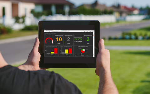
Esri’s out-of-the-box GIS mapping solution provided the team a starting point where they could layer in client-specific data, like utility customer metering information, on top of the parcel data in a new reporting dashboard for enhanced assessment.”
The dashboard includes a mobile application for field teams to navigate to precise locations and track assessment data. Pipe data is automatically uploaded and available in the cloud-based platform. A robust set of reporting tools are built in and ready to export to EPA. Teams can locate and identify new lead and copper pipes, collect and view notes from other users, and tag for additional assessment, if needed.
Utilizing technology and data to make a community more sustainable, equitable, and resilient are foundational elements of smart community planning. VHB specializes in all stages of planning and implementing GIS services that leverage data and technology to solve complex challenges.
“The City of Cayce lead and copper pipe dashboard is a great example of how we can customize a GIS solution for state and local governments to align their initiatives with federal funding and regulatory objectives,” said Kathleen Kewley, ESRI Director for AEC global business development. “In return, governments are more agile and can quickly respond to critical issues of sustainability and equity in their communities.”
To learn more about how VHB helps clients leverage geographic data to make data-informed decisions and deliver innovative geospatial solutions, contact Steve.
Learn how we are making an impact through Technology Services.