

Forward-thinking insights focused on a more sustainable tomorrow.



From Static Studies to Dynamic Tools: A New Model for Mobility Planning
September 2026
Mobility challenges rarely stem from a single failure—they emerge wherever access breaks down between people, places, and services. While these gaps can look different depending on context, each comes down to the same lived experience of someone standing at the edge of a system that almost reaches them.
A commuter who can safely get within a half mile of the station but no closer. A senior whose “last mile” is the distance from a drop-off point to their own front door. A new development with no safe way for residents to reach the train station a quarter mile away.
First- and last-mile access is one of the most visible examples of this challenge, but it is far from the only one. As agencies and communities work to improve connectivity, there is a growing need for approaches that help identify access gaps, prioritize investments, capitalize on funding opportunities, and support more informed decision-making.
Planning for a Moving Target
Traditional planning studies are valuable, but they are ultimately snapshots in time.
Many rely on data that ages as travel patterns, community needs, and transportation options continue to evolve.
Ridership shifts. Development patterns change. Funding opportunities open and close. Technology introduces new ways for people to move.
Every cycle spent re-studying a known problem is a cycle not spent implementing a solution.
This creates a particular challenge when agencies need to act quickly. Communities without current, defensible data are at a disadvantage when competing for limited federal and state funding. A study that is two years old when a grant window opens forces a difficult choice: submit outdated information or start another round of analysis.
As transportation networks adapt to new travel patterns and technology, planning approaches need to keep pace with tools that integrate new data, respond to changing conditions, and extend the value of planning investment over time.
Two Models, Side by Side
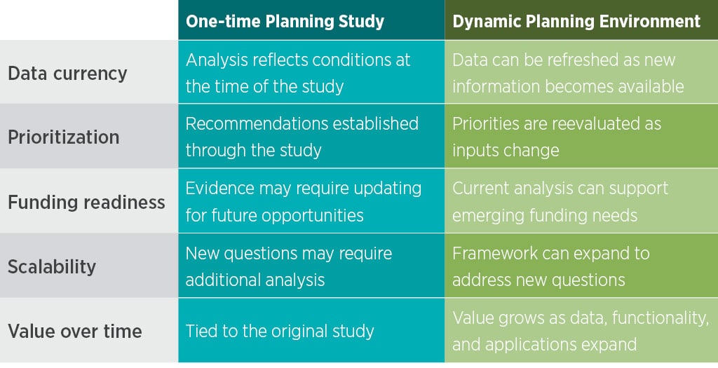
From Static Study to The MTA First Mile Last Mile Toolkit
This challenge became the foundation for an innovative partnership between VHB and the Metropolitan Transportation Authority (MTA).
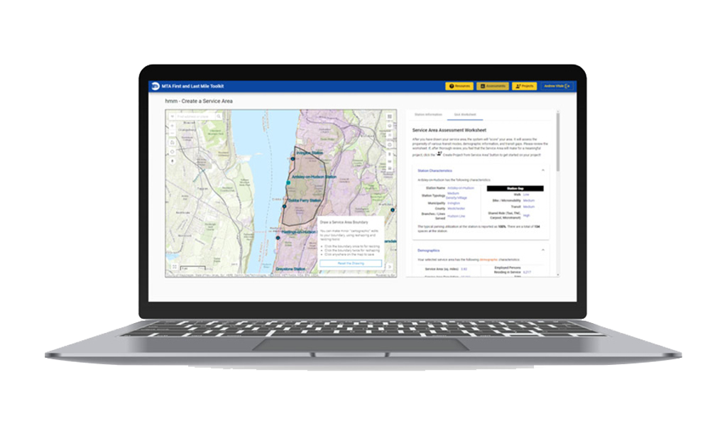
What began as a request for a traditional planning study evolved into a web-based planning tool designed to support ongoing decision-making rather than serve as a static final deliverable.
Built as a spatially enabled, map-centric application leveraging Esri ArcGIS Enterprise technology, the toolkit was developed for municipalities and stakeholders surrounding Metro-North Railroad and Long Island Rail Road stations throughout the Hudson Valley and Long Island.
With it, users can:
- IDENTIFY access gaps across pedestrian, bicycle, and microtransit networks
- VISUALIZE infrastructure improvements such as sidewalks, bike lanes, and traffic-calming measures
- ESTIMATE implementation costs for candidate projects
- EXPLORE funding opportunities and partnership pathways
Watch this video for a quick walkthrough of the toolkit.
At the center of the toolkit is a configurable analytical approach that combines spatial, demographic, network, and observed travel data to identify where gaps exist and where investments could have the greatest impact.
For the MTA application, VHB developed a propensity index and gap score to evaluate first- and last-mile access potential and target specific modes that station areas can improve upon.
The propensity index combines factors such as trail and roadway networks, topography, Census information, and other location-specific variables. Combined with survey data showing how people access stations, these inputs create an evidence-based evaluation of potential opportunities.
The gap score brings those inputs together to help answer two critical questions:
- Where are the greatest opportunities for improvement?
- Which travel modes have the greatest potential to gain rider share?
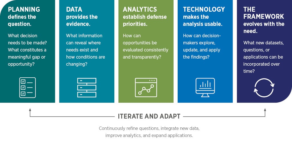
While the specific inputs and analytical criteria can change depending on the planning challenge, the methodology remains the same: combine the right evidence to turn a complex planning question into a repeatable way to identify, compare, and prioritize opportunities.
Planning-Led. Technology-Enabled.
The toolkit represents a different approach to transit and mobility planning, one that combines planning, data, and technology to support better decisions over time.
The framework begins with sound planning practice, including clear objectives, transparent assumptions, professional judgment, and local context. Technology builds on that foundation by organizing complex data and analysis in an accessible format, helping planners, municipalities, developers, and other decision-makers understand conditions, explore potential improvements, and evaluate priorities without needing to interpret raw GIS data.
The toolkit is also designed to remain useful as new information becomes available. Its underlying data and analytical processes can be refreshed over time, with planners reviewing updated results before they are republished. This helps maintain the integrity of the analysis as conditions, priorities, and datasets evolve.
This distinction matters because the goal is not simply to digitize a planning study, but to create a framework that makes planning insights easier to apply, revisit, and refine over time. By connecting sound methodology with technology, communities gain a more transparent and repeatable way to evaluate tradeoffs, prioritize investments, and support future decision-making.
 From Analysis to Action: The Riverhead Story
In Riverhead, New York, the toolkit was used to evaluate pedestrian and bicycle connectivity surrounding the local Long Island Rail Road station, producing a defensible, data-informed case for investment.
That work became a foundational element of the community’s successful $24 million USDOT RAISE Grant application.
Because current analysis was already in hand, decision-makers focused on implementation instead of launching another planning effort—the kind of structured, defensible information funding agencies increasingly expect to see.
Expanding the Framework
Although the toolkit was originally developed to address first- and last-mile access, the underlying framework is not limited to a single mode, geography, or use case.
Because the approach is planning-led rather than tool-led, it can be adapted to a wide variety of mobility and connectivity challenges. The same methodology can scale from a five-county regional initiative to a single corridor, station area, or development site.
The process begins with a simple question:
Where are the access gaps and what is the most direct way to address the issue at hand?
The answer may look different depending on the community, but the planning process remains remarkably consistent.
Potential Applications
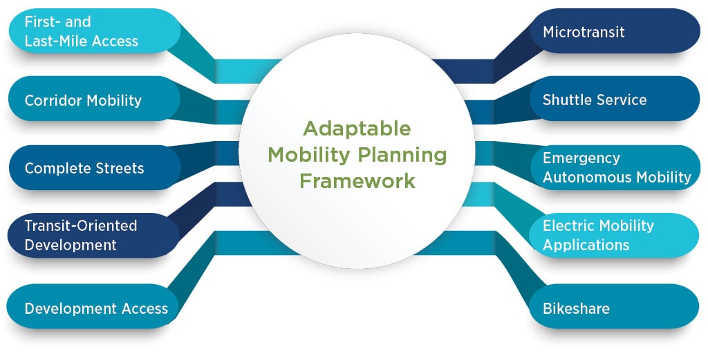
Because the model is built on repeatable analytical methods—and supported by multidisciplinary planning, GIS, and technology teams—it can be tailored to local priorities and datasets without requiring the planning effort to start from scratch.
The same gap that strands a commuter at the edge of a station today is the gap that a microtransit route, autonomous shuttle, or new development will need to address tomorrow. The solutions may differ, but the planning challenge remains the same.
A New Kind of Planning Readiness
Federal and state funding programs are only getting more competitive, and that’s just one version of a broader shift.
Whether the intent is a grant award, development approval, or a board vote, the municipalities and organizations that succeed are the ones that can show up with current, defensible data already in hand.
That’s a different kind of readiness than most planning processes are designed to support.
The goal is about moving towards maintaining a living foundation of digital evidence that can be called upon the moment an opportunity emerges.
That shift is already underway. Those that build standing capacity now—rather than restarting from scratch with every cycle—will be the ones setting the pace for the industry, not chasing it.
How VHB Can Help
The future of planning isn’t about replacing studies with technology. It’s about extending the value of planning so that the work continues to support decisions long after the original study is complete.
VHB brings together planners, engineers, GIS professionals, data analysts, software developers, and technology specialists to help clients build custom decision-support environments around questions that matter the most. As innovative partners and strategic advisors, we help agencies and communities translate complex data into actionable insights, prioritize investments, and build tools that continue delivering value as needs evolve.
Whether the challenge involves first- and last-mile access, corridor mobility, emerging transportation technologies, or development planning, VHB helps clients create adaptable frameworks that support better decisions over time.
Ready to extend the value of your next planning investment? Contact Michael, Matthew, and Andrew today.